Environmental Sensing
The main focus of the CT Environmental Sensing will be the estimation of bio-/geo-physical parameters using different sensing instruments. Different research institutions will participate with their sensing instruments and platforms to the collection of parameter derivations.
The CT Environmental Sensing is defined by the operation of different instruments on different platforms and by the derivation of bio-/geo-physical environmental parameter from these. This information is used as the input for higher order models or land process models in order to reduce their statistical variability and improve their accuracy and reliability. The sensing of the region of interest can be done on a local, regional and/or global scale. Depending on the required information content, the sensing can be done in high spatial resolution (1-10m), on a large scale coverage (swath 15-100km), frequently (daily to monthly), at any time of the day (e.g. radar) and weather independent (e.g. radar). Since ground based measurements are limited in plot size measurable per unit of time, the integration of methods up to the catchment scale within a hierarchical approach is favourable:
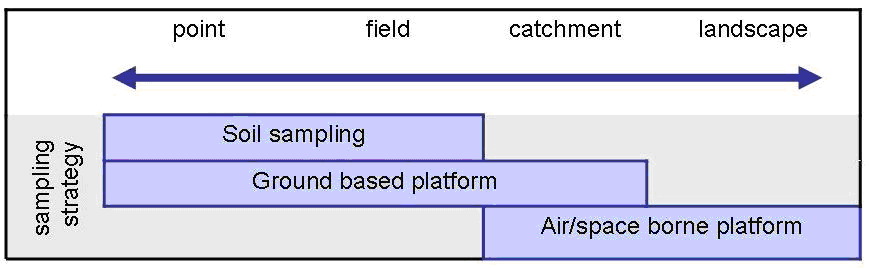
This will include the integration of surface based measurements with geophysical platforms, handheld spectroscopy and sampling at points as well as the up-scaling to spectroscopic measurements and also airborne and spaceborne measurements. In order to reach the research hypotheses the CT Environmental Sensing will follow the approach of the following tasks:
- Collection and coordination of requirements from the different CT's (CT Environmental Sensing is acting as an interface between the other CT's)
- Coordination of flights and instruments over regions of interest
- Coordination of common instrument operation over regions of interest
- Intercomparison of field instruments
- Coordination of airborne/spaceborne data acquisition with ground measurements
- Reporting on data processing status and data quality
- Exchange of inversion procedures for the environmental parameters
- Synergies between different sensors
- Collection, coordination, archiving of different types of data
In order to make measurements from different instruments comparable to each others and to ensure a defined level of quality, cross-calibration of measurement equipment is necessary. For optical measurement systems used for environmental remote sensing DLR Oberpfaffenhofen operates an optical laboratory (CHB - Calibration Home Base) for the calibration of hyperspectral airborne sensors and field spectrometers. This facility will be used by the TERENO partners to characterize the radiometric and spectral properties of their radiometers, IR-cameras, optical cameras, and imaging spectrometers in the spectral range from 380-2500 nm. Equipment is available to investigate irregular instrument properties, e.g. spectral filters for stray light measurements. Furthermore, the partners will bring their own calibration equipment (e.g. radiance standards, reflectance panels for lab and field use) to the CHB for calibration. In addition, optical components from their labs (e.g. spectral transmission of filters) can be characterized spectrally. It is intended to perform annual campaigns in the CHB to characterise and intercompare the instruments of the TERENO partners in the CHB for the TERENO partners. DLR will also purchase and maintain a calibrated field spectrometer for in-situ spectral measurements of radiance, irradiance and reflectance. It is available for the TERENO team to perform validation measurements at the test sites during airborne campaigns. Organisation of calibration campaigns as well as coordination of resources will be covered by the CT Environmental Sensing.
Members
- Irena Hajnsek (DLR)
- Erik Borg (DLR)
- Carsten Montzka (FZJ)
- Wolfgang Junkermann (KIT)
- Sibylle Itzerott (GFZ)
- Angela Lausch (UFZ)
- Andreas Reigber (DLR)