.jpg)
.jpg)
Test Sites
The TERENO Northeastern Lowland observatory comprises four test areas that differ significantly in intensity and history of their land use practices.
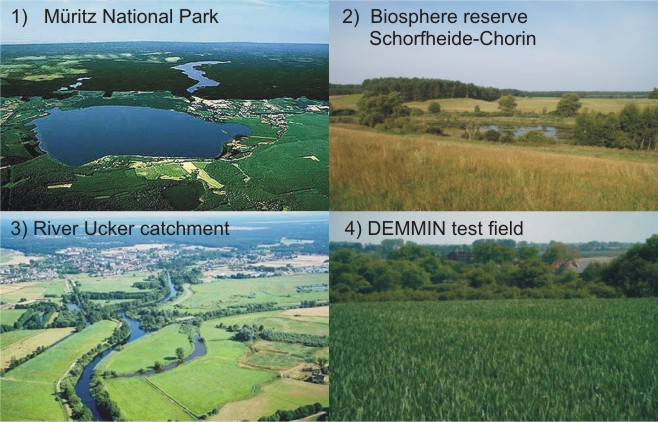
1) the Müritz National Park represents a protected quasi-natural site;
2) the Schorfheide-Chorin Biosphere Reserve is a well controlled cultivated landscape;
3) the catchment of the river Uecker; and
4) the Durable Environmental Multidisciplinary Monitoring Information Network (DEMMIN) operated by the “Deutsches Zentrum für Luft- und Raumfahrt (DLR).
The sparsely populated Müritz National Park (322 km2) was established in 1990 and is considered as quasi-natural. It forms a complex glacial landscape consisting of till plains, terminal moraines and dominating outwash plains. Numerous basins with 107 lakes larger than 1 hectare including Lake Müritz, the largest lake (117 km2) in the northern German Plain as well as peatlands occur. The altitude spans ca. 60-140 m a.s.l. The National Park predominately drains via the upper Havel and Elbe Rivers. The climate is transitional between temperate-oceanic and sub-continental with mean annual temperatures around 8°C and mean annual precipitation between 550 and 630 mm. About 70% of the park’s territory is forested mainly consisting of planted pine forests. Other forested areas consist of dry and wet mixed deciduous forests. The park is zoned in areas of different grade of nature conservation: a core zone of 93 km2 (29%) where any land use is strictly prohibited, a development zone of 219 km2 (68%) which dominantly contains (low-level) managed forests and a cultivation zone comprising extensively used pastures of 10 km2 (3%).
The Schorfheide-Chorin Biosphere Reserve (1290 km2) was established in 1990 and belongs to the young morainic area with all geomorphic elements of a glacially formed landscape (e.g. till plains, terminal moraines, outwash plains, basins). The altitude is ca. 2 to 140 m a.s.l. The area drains both into the Baltic Sea (via Uecker, Randow and Oder Rivers) and into the North Sea (via Havel River). About 230 lakes with a total area of 90 km2 (7%) and numerous peatlands occur. The climate is transitional between temperate-oceanic and sub-continental with mean annual temperatures between 8 and 9°C and mean annual precipitation between 500 and 560 mm. About 650 km2 (50%) of the biosphere reserve’s area is forested dominated by planted pine stands. The natural potential forest vegetation would be dominated by mixed deciduous trees. The biosphere reserve comprises differently protected areas: a core zone of 50 km2 (4%) where land use is strictly prohibited, a buffer zone of 240 km2 (19%) where land use is moderate, and a development zone of 1000 km2 (77%) which still contains intensively managed forests and agricultural land but for which a development plan into more sustainable land use is being implemented. To date 24% of the agricultural land is managed ecologically. About 35,000 inhabitants are living in the biosphere reserve. This corresponds to a very low population density of 27 inhabitants/km2.
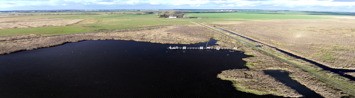
The Uecker catchment in the Pleistocene glacial lowlands within the TERENO Northeastern observatory is characterised by relatively dry conditions (mean precipitation ca. 550 mm, of which roughly 80% are evaporated back to the atmosphere) and by a very tight and direct interaction of ground and surface waters. Many lakes of varying sizes are part of that area, most of which are linked to the terrestrial hydrology only by ground water (no surface runoff). The main land-use type is arable, pasture, or wetlands of high ecological value. The Uecker flows into the Oderhaff, which is a barrier lagoon of the Baltic Sea, so that the northern part of the catchment is almost at sea level. Several parts of the catchment are of high ecological and recreational value, while other parts are agricultural land (often drained), with significant changes of land-use management since the political change in 1989 and the recent increase in bio-fuel crops cultivation.
The DEMMIN test field is considered as a rather heterogeneous and intense agricultural area located approximately 180 km North of Berlin. An area of approximately 30’000 ha is cultivated by a consortium of local farmers (the IG DEMMIN) with whom we have contracted to utilize certain parts of their land properties.
Highly diverse soil properties are present within the DEMMIN test field as is typical for this young glacial landscape. The north-east part of the test field operated by the “Deutsches Zentrum für Luft- und Raumfahrt” (DLR) belongs to the lowlands of Vorpommern. The south-west part lies in the “backland” of the Mecklenburger lake-plateau.